Grapevine Canyon top spot for petroglyphs
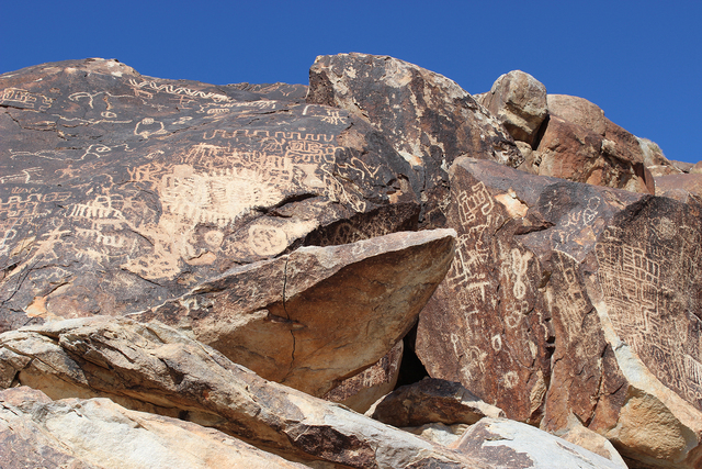
Grapevine Canyon, toward the southern end of Lake Mead National Recreation Area, is said to be among the best of all places to see the intriguing Native American rock art called petroglyphs. It’s certainly one of the easiest to visit. It’s especially good if you want to take small children or other folks who can’t hike long distances, as the best petroglyph panels are at the mouth of the canyon only about one-quarter mile from the parking area.
This is a good time of year to make that visit, for the elevation is about 2,385 feet — just a bit higher than Las Vegas — practically guaranteeing agreeable temperatures. When I was last there, a couple of weeks ago, the wild grapevines were just beginning to show green.
From the trail head just follow the well-worn path toward the canyon, located on a sandy bench above the broad, and usually dry, Grapevine Wash. Once you reach the mouth of the canyon you will find dozens of panels on both sides.
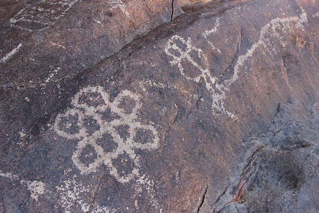
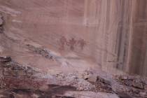
The petroglyph designs were made by pecking away the natural, dark desert varnish on the surface of the cliffs and boulders, exposing the lighter-colored rock beneath. Most of the petroglyphs here seem to be abstract designs or symbols, but there are also some quite recognizable figures, including bighorn sheep and lizards.
Evidence has determined these petroglyphs range from 150 years old to more than 800. It is thought that prehistoric American Indians spent time here starting sometime around A.D. 1100. The Yuman-speaking people of the lower Colorado region consider this sacred ground; it lies only a few miles south of Spirit Mountain, the 5,639-foot peak considered to be their spiritual birthplace.
When you visit a petroglyph site, be aware of the importance of these cultural resources and take care not to harm them. It’s now known that merely touching petroglyphs with fingers will damage them, because the natural oils in human skin are corrosive. Also, do not climb upon or sit on the boulders for a better look. The boulders are often unstable and dislodge easily, which would displace part of prehistory, not to mention possibly injuring someone in your party. Bringing binoculars is the best solution to assuring a close look at less accessible specimens.
Once you’ve had a satisfactory look at the petroglyph panels, it’s a pretty canyon just to stroll up a ways further. If you keep your eyes peeled, you will find a few more art panels here and there.
About 30 yards or so from the mouth of the canyon, further progress becomes more difficult as you will come to a dry fall, choked and surrounded with cliffs and large boulders. If you have small children along, this is where your journey should end.
Those adults looking for more adventure can scramble up the cliff walls and head back down into the canyon above the obstacle. Beware, though; the granite rocks are extremely slippery. Once in the upper canyon you can travel one mile or so and be treated with more delights.
Your route will be primarily along the north side of the drainage, yet you will have to cross to the south side several times as you make your way. You will find thickets of canyon grapes and even a spattering of willow and cottonwood trees. There are seeps and springs in this area so don’t be surprised if you find your feet getting wet, and a bit muddy here and there.
After a while the terrain becomes less vegetated and the walking is easy. But keep traveling a small ways and you will have one last surprise: a small but charming slot canyon. Once you’ve enjoyed it, this is a good place to turn around and head back.
Many of Deborah Wall’s columns were recently compiled with new information and photos in “Base Camp Las Vegas” and published by Stephens Press. She is the author of “Great Hikes, a Cerca Country Guide.” Wall can be reached at Deborabus@aol.com.

